Tail of the Dragon
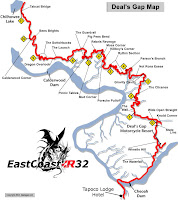
 Are you looking for an adventure? Do you have a motorcycle or sports car? If so then you may want to consider taking a ride to Deals Gap, better known as the "Tail of the Dragon" or just the "Dragon." The Dragon is a popular and internationally famous destination for driving enthusiasts. The Dragon in Tennessee offers up to 318 curves over 11-miles.
 The road earned its name from its curves resembling the tail of a dragon. The stretch bears the street name Tapoco Road in North Carolina and Calderwood Highway in Tennessee and is signed entirely by U.S. Highway 129. Since part of the road is also the southwestern border of the Great Smoky Mountains National Park, there is not development along the 11-mile stretch. The road travels mostly through forested area. Along the route there are a few scenic overlooks and pull off points.
 The speed limit on the Dragon was 55 mph prior to 1992; however, in the 1990s and early 2000s, the limit was reduced a number of times until 2005 when a speed limit of 30 mph was signed along the entire stretch.
To get to the Dragon, you need to travel on 321 to the Foothills Parkway. You can find 321 by traveling through Maryville towards Townsend, or from Pigeon Forge turn onto 321 (Wears Valley RD.) at traffic light #3. Once in Townsend, take a right and continue on 321. Turn onto and follow the Foothills Parkway until you get to 129 and turn left. The Dragon is located on US129 crossing the Tennessee/North Carolina state line.
This trip is not for the weak at heart and can be quite an adventure. If you think you have what it takes to "Tame the Dragon" and are ready for curve, after curve, after curve then good luck and be safe.


Comments